
Somalia
GEMS Area

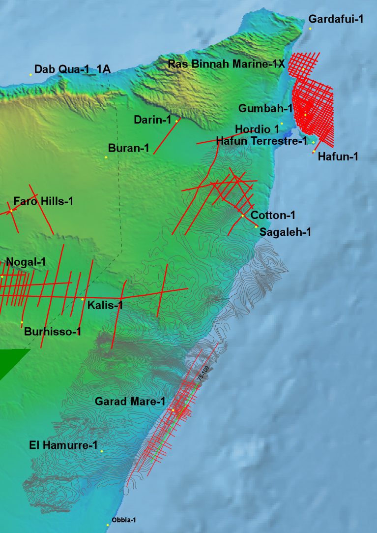
GEMS Area Project Overview, showing seismic and well data.
(A plot of highlighted seismic line 75-109 is shown below)
Uncovering 4 Billion Barrels: The Modernized GEMS Dataset for Offshore Somalia
As the global energy industry focuses on the 1st Somali Licensing Round, the GEMS Area has emerged as a premier frontier opportunity. Designated by Pecten for a group of prospects in, the then, Blocks M-4 and M-5 offshore central Somalia, this region represents one of the most prospective large acreage blocks currently available.
Proven Potential & World-Class Leads
Historical evaluations and modern data restoration have highlighted the massive scale of this province:
- 4 Billion Barrels of Recoverable Oil: This is the estimated potential contained within 19 identified leads and prospects in the GEMS area.
- Untested Compressional Anticlines: The primary play involves a series of large, simple, and faulted folds created by reverse faulting.
- Oman Field Analog: The Middle to Upper Cretaceous carbonates in GEMS are geologically similar to the prolific Fiaud and Natih Fields in Oman, which have produced over 700 million barrels of oil.
- Effective Sealing package: The reservoir section is protected by a thick, world-class Tertiary shale seal averaging 1,400 to 1,450 meters in thickness.
Workstation-Ready Data Inventory
Canesis Data has successfully restored and vectorized the critical archives needed to evaluate these high-relief structures:
- Vectorized Seismic: A high-resolution grid of 2,036 line kilometers of wave equation migrated 2D seismic data (SEGY format) from 1975 and 1989 surveys.
- Digital Well Control: Digitized logs and comprehensive curves for the pivotal offshore well Garad Mare-1 and two nearby onshore wells.
- Reservoir Insights: Petrophysical analysis of Garad Mare-1 confirms over 1,300 feet of porosity (averaging 20-31%) in the Middle to Upper Cretaceous carbonates.
- Integrated Technical Reports: The dataset includes gridded gravity and magnetic data from Conoco aeromagnetic surveys, alongside specialized reports on biostratigraphy, geochemistry, and tectonics.
Regional Context & Licensing
The Somali government has ratified petroleum laws and established the Somali Petroleum Authority (SPA) to oversee offshore exploration and development. For operators seeking a comprehensive basin-wide assessment, Canesis also provides extensive data coverage for the onshore part of the basin, including over 3,300 km of seismic and log suites across Blocks 27, 28, 29, 31, and 34.
Recent roadmap agreements with industry leaders like Shell and ExxonMobil underscore the renewed international confidence in Somalia’s offshore potential.

Plot of vectorised seismic line 75-109
Total magnetic intensity cover over GEMS and adjacent areas.